

At least 16 dead as tornadoes, flooding ravage several states in central US
CAPE GIRARDEAU, Mo. - A relentless barrage of tornadoes and historic flash flooding across several states has now claimed at least 16 lives, according to state and local officials.
The latest death occurred near the town of Boston, Kentucky, where the Nelson County Sheriff's Office said a 74-year-old driver was found dead Saturday morning in their vehicle after authorities responded to a call for a water rescue. Authorities have not identified the victim.
At least 10 of those deaths happened in Tennessee, state officials said. On Thursday, President Donald Trump approved the disaster declaration for all 95 counties in Tennessee, setting in motion FEMA's response to disaster relief across the state.
Life-threatening flooding and dangerous severe weather pummeled large swaths of the nation's heartland again Friday night for the third night in a row, and Saturday is shaping up to be just as bad, if not worse, for some areas with worries of heavy rainfall not seen in generations.
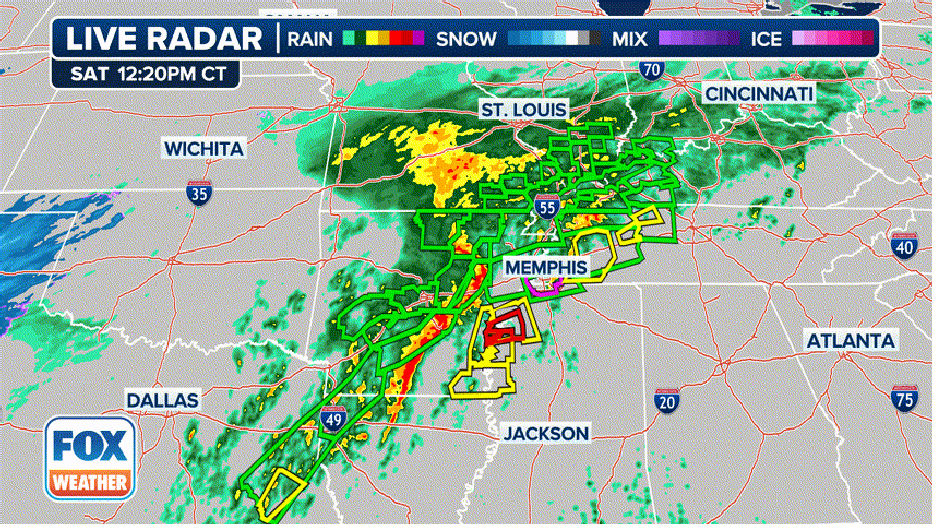
In a sign of what could be yet to come for many this weekend, torrential rains stalled over southeastern Missouri and the Texarkana region of northeastern Texas and southwestern Arkansas on Friday night, triggering multiple Flash Flood Emergency warnings - the National Weather Service's most dire flooding alert.
In Missouri, tens of thousands in Cape Girardeau and Van Buren were under flooding emergency Friday night. Cape Girardeau reported over 3 inches of rain in just over 90 minutes late Friday evening in one burst, with emergency managers reporting at least 10 roads covered in water and ongoing water rescues.
Farther south, forecasters issued similar dire warnings for Texarkana, where 2-4 inches of rain fell, and water rescues were ongoing.
Texarkana police were responding to stranded motorists on Friday night across the Texas city during the Flash Flooding Emergency.
"We’re just gonna lay it out there … If you don’t have a darn good reason for being out (like one that involves a visit to the emergency room), please stay home and off the roads!! This is not just another Friday night in Texarkana," the Texarkana Police Department wrote on Facebook.
Earlier in the day, officials in Hopkinsville, Kentucky, reported 60% of their downtown area was underwater.
The flooding has swamped numerous homes and submerged cars in Hopkinsville.
"It’s destroyed. I can’t salvage anything out of it," said Paul Garrett, a Hopkinsville resident whose home was flooded. "I’ve lived here a long time, and this is the worst I’ve ever seen it. The weather crew has been good about warning us about things. Take it for granted or not, you just wind up at the wrong place at the wrong time."
About 120,000 people remain without power in Arkansas as of Satruday afternoon, according to FindEnergy.com
Meanwhile, dozens of Tornado Warnings wailed across the Lower Mississippi Valley and into northeastern Texas as a stalled frontal system spawned a renewed round of severe thunderstorms and super cells.
Significant damage to structures was reported around Clarksville, Texas, but there were no immediate reports of injuries.
Spotters reported to the National Weather Service office in Shreveport, Louisiana, that a bottling plant in Hawkins, Texas, was damaged by a nearby tornado strike.
The tornado was part of a series of supercells tracked by National Weather Service meteorologists across East Texas. It followed nearly the same path as the twister that struck the plant in 2016.
There have been no reports so far of any reports of injuries from Friday night's storms.
But at least nine people have died from the multiple severe weather and flooding events through the week as a massive storm system remained stuck over the central U.S. A 9-year-old boy was killed Friday morning in Frankfort, Kentucky when he was swept away by floodwaters on his way to school.
Catastrophic flash flooding threatens millions Saturday
The dire flooding threat stretches through the weekend. Repeating rounds of rainfall will lead to potentially historic amounts, particularly focused on the lower Ohio Valley, mid-South and Ozarks, according to the FOX Forecast Center.
Storm total rain amounts of 5-15 inches are likely, and some locations may see up to 20 inches. Rainfall rates of 2 inches per hour or more will lead to rapid-onset flash flooding, leaving people caught off guard by the speed of water rise.
Since Monday, over 9 inches of rain has fallen in Lewisburg, Kentucky, with just over 7 inches in Bowling Green, nearly 7 inches in Memphis and nearly 4 inches in Nashville.
Deadly floods submerge homes and cars in north Arkansas
Deep floodwaters submerged buildings and vehicles in Hardy, northern Arkansas, as the National Weather Service warned of "life-threatening flash flooding" on Saturday morning, April 5. (Joey Fishing via Storyful)
A category 4 risk for flash flooding – the highest level on the warning system – remains in effect for more than 5 million people through early Sunday morning. That includes large cities like Little Rock, Jonesboro, and Memphis.
Nashville is just outside that zone in a level 3 flash flood risk.
"Saturday is the day that concerns me the most right now," said Meteorologist Ryan Husted with the National Weather Service in Nashville. "Because we have time for our atmosphere to recharge, which means we have the potential for dangerous severe thunderstorms once again. In addition, our ground is saturated -- that means any rain that falls will run off and it’s going to cause flooding. I’m very confident that Saturday is a dangerous day for flash flooding going into Saturday night."
Flood Watches are in effect for nearly a 1,000-mile stretch that includes parts of 12 states. The amount of rain will also trigger flooding in areas that do not usually flood, according to NWS forecasters.
In addition to flash flooding, extensive river flooding is feared. NOAA's Water Prediction Center has placed 45 rivers in the region forecast to reach major flood stage, with over 110 others expected to reach at least moderate flood stage.
"Impacts from this event will be significant and may be historic," said meteorologists with NWS Paducah.
Even long after the rain ends on Sunday, the flood impacts will be far from over. All the water will continue to surge into progressively larger streams and rivers across the region.
These, in turn, will rise through the weekend and even into next week. Houses that did not flood when the rain was falling may find themselves underwater days later.
As the water eventually drains into the Mississippi and Ohio Rivers in the days and weeks ahead, some flooding is likely downstream. Waters in Baton Rouge, Mississippi may reach the highest level in four years later this month, according to the FOX Forecast Center.
Severe weather remains a threat over the weekend
As has also been the case much of the week, multiple rounds of severe storms producing damaging winds and a few tornadoes are forecast for Saturday and Saturday night from the Sabine Valley into the mid-Mississippi and Ohio Valleys. Some strong tornadoes (EF-2+), very large hail, and severe gusts above 70 mph will be possible.
The day will be active right from the start, as storms line up from northeast Texas up into the Ohio Valley. Flooding rain, quarter-size hail, and a few 60+ mph wind gusts will be the primary concerns.
As the day goes on, a notable risk of tornadoes will be in place across northern Louisiana, central Mississippi, and far northeast Texas. Finally, a notable increase in the threat for damaging non-tornadic winds will exist from western Tennessee down as far south as the Houston metro. Wind gusts from these storms may top 75 mph.
Overall, NOAA's Storm Prediction Center has a large swath of the Lower Mississippi Valley into the Tennessee and Ohio Valleys – many of the same areas simultaneously under threat of historic flash flooding under a level 3 out of 5 risk for severe weather. However, there is a new heightened level 4 risk now in effect around Memphis due to worries of potential for strong tornadoes and wind gusts over 75 mph from an approaching squall line.
The line of storms will charge across Mississippi and Louisiana overnight with primarily a damaging wind threat. A couple of tornadoes will be possible as well.
Severe weather will continue into early on Sunday and move across parts of the Gulf Coast states and Tennessee Valley.
Read more of this story from FOX Weather.