Houston weather: More wet weather expected Wednesday morning
Street Flooding and Strong Storm Threat
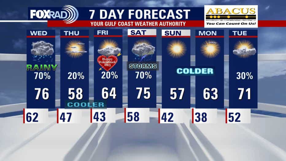
HOUSTON - While we are not expecting a widespread outbreak of severe storms or flooding, some spots, especially along and north of I-10 could receive 3-4" of rain, so street flooding is possible tonight through early Wednesday. 1-2" of rain should be common with a few streaks of 3-4".
Chilly air on the way
A cold front will move through Wednesday afternoon & evening that will sweep the rain and fog away and bring a few chillier days. It won't be frigid and freezing temps aren't likely, but for Thursday and Valentine's Day Friday, expect lows in the 40s with chilly winds. Highs could be stuck in the 50s on Thursday and 60s on Friday. A few isolated showers are possible as well.
Get news, weather and so much more on the new FOX LOCAL app
More rain this weekend
A line of storms could kick off the holiday weekend with strong storms & heavy downpours on Saturday. That system should move through fairly quickly and will be followed by more chilly air. Lows could fall into the upper 30s and low 40s on Sunday morning and a very light freeze is possible north of Houston on Monday (Presidents Day) morning.
Download our FOX 26 Weather App to keep track of the latest alerts on flooding and any strong storms in your area.