

Houston weather: Hot weather this week, stormy weekend possible
LATE SPRING-LIKE WEATHER THIS WEEK
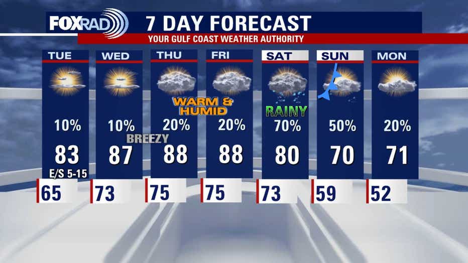
HOUSTON - A brief north breeze today will drop humidity slightly on Monday, but temperatures will still run 5-12 degrees above average today through Friday. Winds will increase from the south tomorrow, and it looks like a very breezy and muggy pattern Wednesday through Friday. A few stray showers are possible each day, but most storms should stay north of our area. A few strong storms could brush our northern counties briefly Wednesday evening, but the majority of it should stay out of the area.
WEEKEND STORMS EXPECTED
A cold front is expected to arrive either Saturday into Sunday, so a round of storms is very likely. For now, it's a bit early to be very confident about exact timing, but prepare for storms any time from midday Saturday through midday Sunday. The weekend rainfall should be the only significant rain for the next 10 days or so.
MUCH COOLER NEXT WEEK
Amazingly, after highs in the upper 80s most of this week, next week we could have highs near 70 with lows in the 50s, so if you've already had enough of the warm and muggy air, this may be one last chance for a while to enjoy a refreshing "burst" of cooler air.
The Source: Information from your Gulf Coast Weather Authority team.