


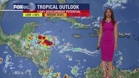
Tropical Weather Forecast - November 7, 2023
There's more good news today concerning the tropics. No tropical cyclones are anticipated across the Atlantic Basin or central/eastern Pacific for the rest of this week! That means the tropics are quiet for now. But hurricane season is still officially here until the end of November. But as expected towards the end of the season, things are finally calming down! Let's hope it stays that way for a few more weeks!
Tropical Weather Forecast - November 6, 2023
As we go into our last three weeks of the 2023 hurricane season, things have finally calmed down! At this time, there's no tropical activity in the Atlantic, Gulf of Mexico, Caribbean or Eastern Pacific. No tropical cyclone formation is expected in the next 7 days. Water temperatures are starting to get cooler in parts of the Gulf of Mexico which signals that the end is getting closer! Hurricane season ends on November 30th! So far, we've had 20 names storms, 7 hurricanes and 3 major hurricanes.
Tropical Weather Forecast - November 5, 2023
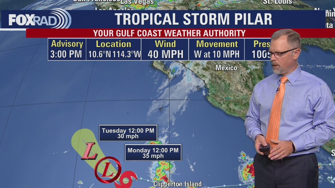
In the Eastern Pacific Pilar remains a tropical storm but not for long. In the western Caribbean, a large area of disorganized showers and storms brings heavy rain to parts of Central America.

Tropical Weather Forecast - November 4, 2023
FOX 26 Chief Meteorologist Mike Iscovitz shares a tropical weather update for November 4, 2023.

Tropical Weather Forecast - November 3, 2023
There are still a few systems to track in this last month of hurricane season. Invest 97-L in the western Caribbean remains disorganized and time is running out for it to become a Tropical system before it reaches Central America tonight or Saturday. At this point, development into a tropical depression or storm is unlikely. But some heavy rain for portions of Central America remains possible the next few days. In the Eastern Pacific, Tropical Storm Pilar continues to race away from Central America & Mexico as it moves W. Things are still quiet in the Atlantic and Gulf of Mexico.

Tropical Weather Update - November 2, 2023
We are into the last month of hurricane season with a few systems that could cause problems. Invest 97-L in the central Caribbean is now down to only a 20% chance of development over the next few days. It continues to track west towards Central America and should reach the eastern coast of Central America by late Friday or Saturday. Even if it does not become a tropical depression or storm, it will still bring the threat of heavy rain to parts of Jamaica and Central America. Tropical Storm Pilar is still moving away from the west coast of El Salvador as impacts subside.

Tropical Weather Forecast - November 1, 2023
We are officially into November and down to the last month of our hurricane season! Gulf of Mexico and tropical Atlantic remain quiet for now. But a disturbance in the central Caribbean could be our next tropical depression or storm. In fact, there's a medium chance for Invest 97-L to reach tropical cyclone status over the next week. The next name would be Vincent. In the Eastern Pacific, Tropical Storm Pilar is now moving west away from Central America. But heavy rain is still a threat.

Tropical Weather Forecast - October 31, 2023
Invest 97-L is being monitored in the eastern Caribbean. Right now, there's a low chance for development over the next few days but a higher chance that this area of showers and storms could form into a tropical depression or tropical storm over the next 7 days. It is moving west and would be named "Vince" if it developed into a tropical storm. Elsewhere, Gulf of Mexico and Atlantic are quiet for now. In the eastern Pacific, Tropical Storm Pilar is bringing heavy rain to parts of Central America. It will brush by the coast of El Salvador before turning away and moving west later this week. Hurricane season runs through the end of November so stay alert!

Tropical Weather Forecast - October 30, 2023
There's still about a month left in hurricane season with a few systems we are still monitoring. An area of low pressure in the SW Atlantic now has only a low 10% chance to develop as it tracks NW. Another disturbance in the eastern Caribbean has a medium 60% chance of forming into a tropical depression or tropical storm over the next week. The next name on the list would be Vince then Whitney. Tropical Storm Pilar has formed in the eastern Pacific southwest of El Salvador and is expected to bring some heavy rain to parts of Central America over the next few days before moving away from the coast.

Tropical Weather Forecast - October 29, 2023
Tammy has become post-tropical east of Bermuda and the last advisory has been issued. However, a broad area of low pressure in the SW Atlantic has a 60% chance of developing into a tropical depression or tropical storm over the next few days. Another area of low pressure may develop in the SW Caribbean but the chance is pretty low at this point. The next name on the list would be Vincent. In the eastern Pacific, tropical depression 19-E is expected to become a tropical storm and head toward the coast of El Salvador in Central America by the middle of the week. Heavy rain is the main threat. Hurricane season runs through November 30th.

Tropical Weather Forecast - October 28, 2023
Tropics remain active with tropical storm Tammy still east of Bermuda. It is expected to push east then southeast as it weakens to a remnant low over the next few days. A few other areas of low pressure are being monitored for possible tropical cyclone development in the SW Atlantic and western Caribbean. The chance for both of these broad areas of low pressure to develop into a tropical system is low, around 20% or less. They are both drifting north. Gulf of Mexico remains quiet for now. But hurricane season runs through the end of November so stay alert!

Tropical Weather Forecast - October 27, 2023
Tammy is back! And there is even more areas to monitor in the Atlantic basin. It looks like we may be able to check another name of the list in 2023.

Tropical Weather Forecast - October 26, 2023
The aftermath of Otis is becoming more clear, a historic hurricane hitting Mexico. And Tammy is now post-tropical but perhaps not for long.

Tropical Weather Forecast - October 25, 2023
Hurricane Otis made landfall as a monstrous Category 5 hurricane this morning around Acapulco, Mexico. It has quickly weakened to a tropical storm but caused massive damage to parts of southern Mexico. In the Atlantic, Tammy remains a hurricane but is expected to lose tropical characteristics by tomorrow. Tammy will be weaker but should get closer to Bermuda by this weekend. The Gulf of Mexico & Caribbean remain quiet at this point. But remember that hurricane season runs through the end of November so stay alert!

Tropical Weather Forecast - October 24, 2023
As we push into the last week of October, the tropics are still pretty active with hurricane Tammy in the Atlantic. Tammy is moving away from the Caribbean Islands but could bring some gusty winds and heavy rain to Bermuda by this weekend. Tammy is expected to lose tropical characteristics by Thursday. Tropical Depression 21 made landfall in Nicaragua and is quickly weakening. In the eastern Pacific, Otis has become a major hurricane and is expected to hit parts of southern Mexico by Wednesday.

Tropical Weather Forecast - October 23, 2023
We are getting closer to the end of hurricane season but the tropics remain pretty busy! Tammy remains a hurricane now pushing away from the Lesser Antilles. It is expected to become post-tropical by Thursday and get close to Bermuda by Saturday. Tropical Depression 21 has formed in the SW Caribbean very close to Nicaragua. It will make landfall on the eastern Nicaraguan coast tonight with heavy rain and flooding the main threat. In the eastern Pacific, Norma has weakened to a remnant low after making landfall in Mexico over the weekend. Some of the tropical moisture from Norma continues to push into parts of Texas. Tropical Storm Otis is expected to make landfall in southern Mexico late Tuesday into early Wednesday.

Tropical Weather Forecast - October 22, 2023
Hurricane Tammy continues to soak the Leeward Islands but has begun to move off to the north. Norma is a strong tropical storm, now starting to hammer mainland Mexico. Norma is also expected to impacted Texas and other parts of the United States.

Tropical Weather Forecast - October 21, 2023
Two hurricanes to discuss. One in the Atlantic and one in the Pacific. And the National Hurricane Center is also watching another area in the Southwest Caribbean for possible tropical development.

Tropical Weather Forecast - October 20, 2023
Tropics remain active with two hurricanes that we are currently tracking! There's Hurricane Tammy in the Atlantic and Hurricane Norma in the eastern Pacific. Tammy is expected to hit parts of the Lesser Antilles today and tomorrow before turning north. Damaging winds, large swells and several inches of rain will be possible that could lead to flooding. Guadeloupe remains under a hurricane warning with a tropical storm warning for Dominica. Tammy should stay away from the United States as it turns north then northeast early next week. Hurricane Norma is a major hurricane just west of Mexico. It is moving north and should hit the southern tip of the Baja Peninsula this weekend. Some of the moisture from Norma will spill into Texas early next week. Another broad area of low pressure in the SW Caribbean is being monitored for tropical development. But the chance is only 10-20% for now as it moves west. This system should push into Central America early next week.

Tropical Weather Forecast - October 19, 2023
Things remain fairly active across the Atlantic and eastern Pacific. Tropical Storm Tammy is getting stronger and is moving closer to the Lesser Antilles where some hurricane watches, tropical storm watches, and tropical storm warnings are in place. Tammy is expected to bring heavy rain and strong winds to some of the Caribbean Islands Friday and Saturday before making a sharp turn to the north. That will take it away from the United States. In the Eastern Pacific Hurricane Norma has blown up to a major hurricane and should clip the southern tip of the Baja California Peninsula this weekend. We could end up getting a bit of the tropical moisture from this system early next week. Gulf of Mexico waters are still warm but there are no tropical systems expected as of now. Hurricane season runs through the end of November.