

Houston weather: Warm Wednesday ahead of wet Thursday and Friday, FOX 26 Storm Alert Days issued
HOT SUNSHINE TODAY
HOUSTON - Clear skies and light winds have allowed high temperatures to range from the low 80s to the low 90s with most Houston area highs near 90. As is typical on sunny days with light winds in the Houston area, ozone pollution is likely, so the Texas Commission on Environmental Quality has issued an air quality alert level orange - unhealthy for sensitive groups. Most people will not be affected, but those with sensitive lungs should not exert themselves outdoors this afternoon. This is a very common advisory, and we will have dozens of these in the weeks and months to come.
ANOTHER FOGGY MORNING FOR SOME
Wednesday will be another foggy start for parts of Southeast Texas, especially towards the coast. Temperatures once again will soar well into the 80s by the afternoon with a few more clouds around.
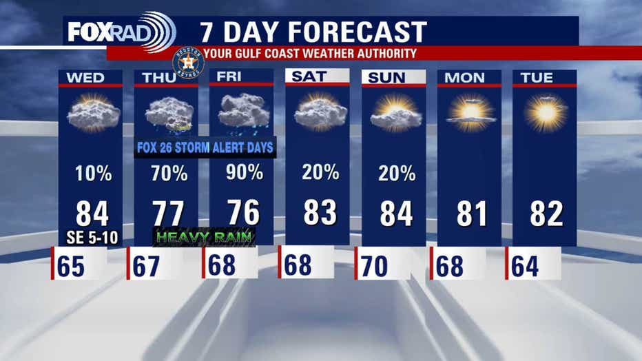
CONCERNS FOR HEAVY RAIN THURSDAY AND FRIDAY
We have labeled Thursday and Friday as Fox 26 Storm Alert Days due to the potential for heavy rain & storms. It looks like waves of heavy rain could bring more than 5" to some locations, but the exact timing and location is still uncertain. Flood Watch has already been issued SW of Houston that includes Victoria & Corpus Christi from Wednesday afternoon until noon Friday. In general, prepare for ugly weather beginning mid to late Thursday morning and into at least Friday evening. Rain totals will vary, but may be heavy enough to cause some flooding, so check back for updates on a developing weather setup. Houston is in a two out of four Flash Flood risk both Thursday & Friday.
QUIET WEATHER FOR THE WEEKEND
So far, it looks like a partly cloudy and warm weekend with highs in the 80s and only isolated showers expected.
Stay up-to-date on the latest weather where you live by downloading the FREE FOX Local app on your phone and smart tv.
The Source: Information provided by Your Gulf Coast Weather Authority team.