

4 Southeast Texas tornadoes confirmed in Harris, Fort Bend, Brazoria, Liberty counties
HOUSTON - Four tornadoes roared across Southeast Texas on Tuesday, leaving damage across multiple counties, the National Weather Service confirms.
On the southeast side of Harris County, a strong tornado damaged homes and businesses and downed power lines. Another was confirmed to the northeast in Liberty County. The agency also confirmed two weaker tornadoes in Fort Bend County and Brazoria County.
MORE: Houston weather videos: Shocking footage of floods, heavy rain and tornado damage
Here’s a look at the preliminary damage surveys that the National Weather Service released on Thursday.
Southeast Harris County tornado
NWS releases details of Tuesday's tornado; damage from Houston to Baytown
The National Weather Service released their first detailed update of ongoing preliminary damage surveys for a tornado that left a trail of damage from southeast Houston to Baytown on Tuesday.
A strong tornado left a trail of damage from southeast Houston to Baytown as it traveled more than 18 miles, according to the report. At its widest, the tornado was just over a half-mile wide.
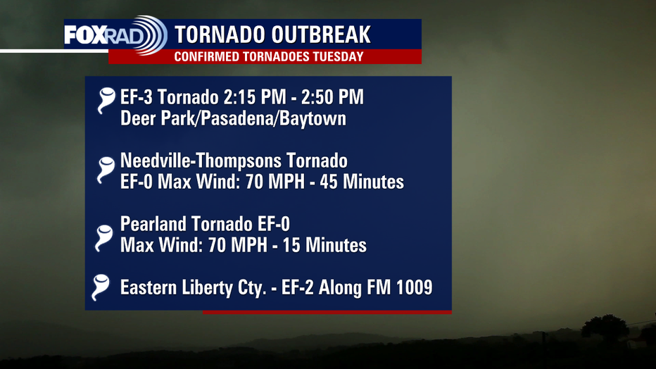
The report rates the tornado as an EF3 at its strongest with an estimated peak wind of 140 mph.
According to the survey, the tornado touched down near El Franco Lee Park, just northeast of Pearland, around 2:15 p.m. and traveled northeast from there. There was damage across parts of southeast Houston, Pasadena, Deer Park and Baytown.
The report states that the tornado was on the ground for 35 minutes, weakening near Baytown where damage estimates were assessed at EF-1 and 110mph winds.
MORE: Preliminary report for Tuesday's tornado details damage over 18 miles
The NWS lists most of the damage between EF0 and EF1 ratings with tree, fence and minor roof damage; however, other spots were rated with more severe EF2 damage like the Beamer Apartments in Houston, some homes in Pasadena, and a church in Deer Park.
The survey showed that the worst of the damage was between Pasadena and Deer Park. The NWS says an aerial survey showed three high tension electoral towers flattened northeast of Deer Park, suggesting EF3 damage.
A mobile home and a single family home were destroyed along Weaver Street in Baytown, the report states.
The agency says the damage became spotty and less intense from there as far north as I-10, but no damage was seen north of the interstate.
Harris County Judge Lina Hidalgo makes statement after EF3 tornado rips through Pasadena, Deer Park
FULL VIDEO: Harris County Judge Lina Hidalgo provides more information after a very destructive tornado moved through Pasadena and Deer Park on Tuesday afternoon.
Needville-Thompsons tornado in Fort Bend County
The NWS confirms that a tornado touched down in Fort Bend County on Tuesday.
The preliminary report rates the tornado as an EF0 with an estimated peak wind of 70 mph.
According to the survey, the tornado touched down near FM 1994 and Fairchilds-Long Point Road, about five miles east-southeast of Needville.
The tornado’s path was 14.5732 miles long, and the tornado was 100 yards wide at its widest.
After touching down at 1:45 p.m., the tornado went northeast toward Thompsons Oil Field and into Sienna, the report states.
Most of the damage was uprooted trees or broken limbs, downed fences, and minor damage to roofs or siding, according to the report.
It was on the ground for 45 minutes.
MORE: Tornadoes aren’t uncommon in the Houston area but strong ones are
Pearland tornado in Brazoria County
The NWS says EF0 damage was observed in southwest Pearland from the intersection of CR90 and Bailey Avenue northeastward toward Magnolia Parkway – a 2.45 mile path. The tornado was about 50 yards wide at its widest.
Starting around 2:10 p.m., the tornado – with an estimated peak wind of 70 mph – left a path of damaged trees and fences.
According to the report, the most significant damage was along Crescent Drive, where some homes had minor roof and window damage.
It was on the ground for 15 minutes.
Eastern Liberty County tornado
The NWS says a tornado struck a home along CR 1009 in Liberty County near the Jefferson County line.
According to the preliminary report, the house sustained EF2 level damage with the roof removed and windows shattered. Mud was splattered on the sides of the home.
Residents, who sheltered in an interior bathroom, reported heavy rain and very high winds during the tornado passage, the report states. The residents were not hurt, but a horse was injured by debris.
According to the report, the tornado was only on the ground for about a minute at 3:27 p.m., and the path was .33 miles long. It was 50 yards wide at its widest. The estimated peak wind was 125 mph.
The NWS says debris was lofted at least two miles north.